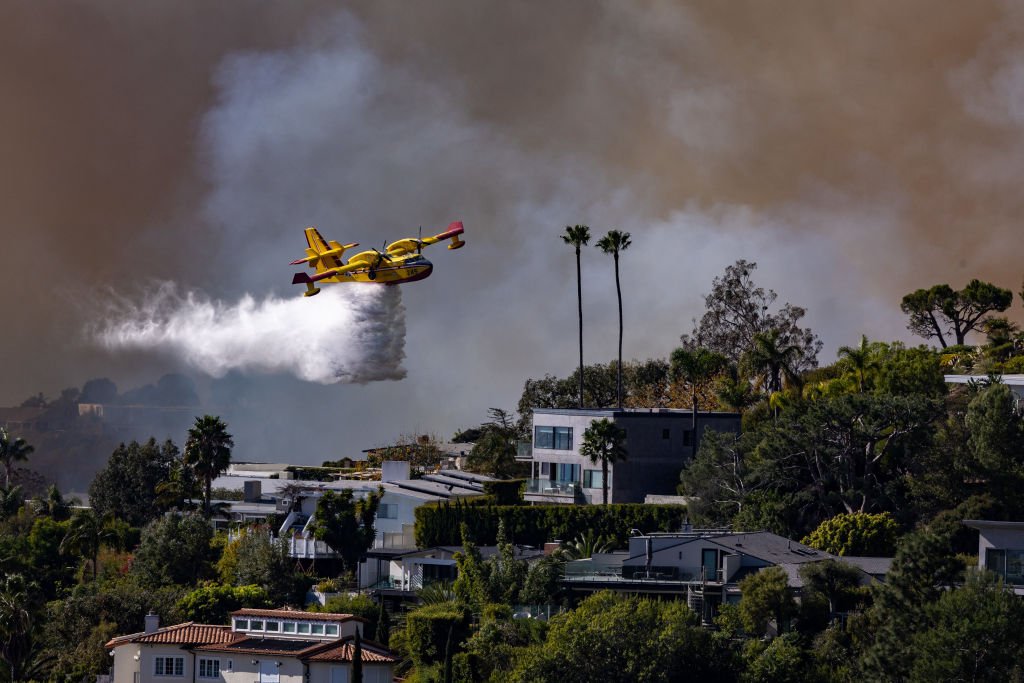
“We hit a drone this afternoon, first one. Our Super Scooper hit a small drone.”
– L.A. County Fire Chief Anthony Marron
Last year in Calicfornia, a Canadian Super Scooper assigned to wildfire suppression was struck by a civilian drone while operating the Palisades Fire. The aircraft was damaged and removed from service for repairs. In the middle of a major fire fight, one of the tools designed to protect lives, homes, and critical infrastructure was suddenly unavailable because someone chose to put a drone into active emergency airspace.
Officials on the ground were blunt about what had happened. L.A. County Fire Chief Anthony Marrone told reporters, “We hit a drone this afternoon, first one. Our Super Scooper hit a small drone.” He then made the consequence painfully clear: “It’s grounded now.” The Los Angeles Fire Department separately reported that Super Scooper Quebec 1 had been struck by a civilian drone not assigned to the fire, and that the aircraft was unable to fly until repairs could be made.
The warning from fire and aviation authorities was equally direct. The FAA has stated that when people fly drones near wildfires, fire response agencies often ground their aircraft to avoid the potential for a midair collision. CAL FIRE reinforced the same message in public incident updates, telling the public, “if you fly we cannot.” That is not public relations language. It is an operational reality. When an unauthorized drone enters the airspace, commanders may have no choice but to slow, divert, or stop flight operations until they can determine whether the threat has passed.
What makes that especially infuriating is that officials have already connected this behavior to real-world damage, real operational degradation, and real risk to the public. In announcing the later criminal case, Acting United States Attorney Joseph McNally said the drone operator had recklessly flown into airspace where first responders were risking their lives to protect lives and property. He warned that the damage to the Super Scooper was a stark reminder that drones flown during emergencies pose an extreme threat to personnel and compromise the ability of police and fire agencies to conduct operations. That is exactly the point. This is not a hypothetical hazard. It is a documented one.
That incident should have been a wake-up call for everyone. Unauthorized drone activity around wildfires is not a minor nuisance, and it is not a harmless mistake. It is a direct threat to aviation safety, wildfire suppression, and public protection. When a drone appears near an active fire, the consequences begin immediately. Aircraft cannot simply continue operating as though nothing happened. Pilots, air attack, and incident leadership have to assume the drone poses a real collision hazard, because it does.
When that happens, the mission changes. Aircraft may be forced to hold, divert, or land. Water drops stop. Retardant missions are interrupted. Reconnaissance becomes more difficult. Helicopter operations may pause. Ground crews who depend on aerial support lose one of the most valuable tools available to them. Meanwhile, the fire does not slow down. It keeps moving, keeps growing, and keeps consuming whatever is in its path.
This is the operational reality Incident Commanders face today. If a drone is sighted, they are often forced to make immediate decisions based on incomplete information. A pilot may report a visual sighting. A lookout may see something briefly. Someone on the ground may call in a possible drone near the incident. At that point, command staff know there may be a threat in the airspace, but they may not know exactly where the drone is, where it is headed, who is operating it, or whether it is even still in the area. That uncertainty is dangerous, and it drives conservative decisions for good reason. No responsible Incident Commander is going to risk a midair collision between a drone and a manned firefighting aircraft.
The problem is that uncertainty has a cost, and it compounds quickly. Every minute that aerial assets are delayed gives the fire more time to spread. A spot fire can grow. A flank can intensify. Winds can push fire toward neighborhoods, businesses, power infrastructure, transportation corridors, and evacuation routes. What might have been slowed or contained with aggressive early aerial intervention can become a larger and more destructive incident simply because aircraft had to stand down.
The financial cost alone can be staggering. There is the cost of aircraft damage and repair. There is the cost of taking a specialized aircraft out of service during a time of urgent demand. There is the cost of operational disruption across the incident. There is the cost of extended suppression efforts as fires grow larger and require more personnel, more equipment, and more days on the line. There is the cost of homes destroyed, businesses lost, infrastructure damaged, and communities displaced. Taxpayers ultimately bear much of that burden, but the deeper cost is measured in risk, disruption, and loss.
The safety impact is even more serious. Firefighters on the ground count on aerial support to slow fire behavior, cool hot spots, support structure protection, and give them a better chance to work effectively and survive changing conditions. When those aircraft are unavailable, firefighters are exposed to greater danger. Residents waiting under evacuation warnings or orders lose precious time. Law enforcement and emergency management personnel face more difficult conditions. In the worst cases, a drone intrusion can help create the kind of delay that turns a manageable situation into a life-threatening one.
This is why the common public messaging, “If you fly, we can’t,” matters so much. It is not a slogan. It is the plain truth. Unauthorized drones in incident airspace interfere with the aircraft that are trying to save lives and property. They reduce the effectiveness of the response precisely when speed, coordination, and visibility matter most.
What makes this problem so frustrating is that Incident Commanders and air operations teams often have very limited tools for understanding it in real time. A reported drone sighting may be accurate, but still incomplete. It may tell you there is a problem without telling you enough to solve it quickly. Is the drone inside the operational area or outside it? Is it moving toward aircraft operations or away from them? Is it being operated nearby? Is it a legitimate public safety platform or a civilian aircraft where it should not be? Is there one drone or more than one? Those questions matter, and right now they are too often answered slowly, indirectly, or not at all.
That is where PerimeterScope changes the equation.
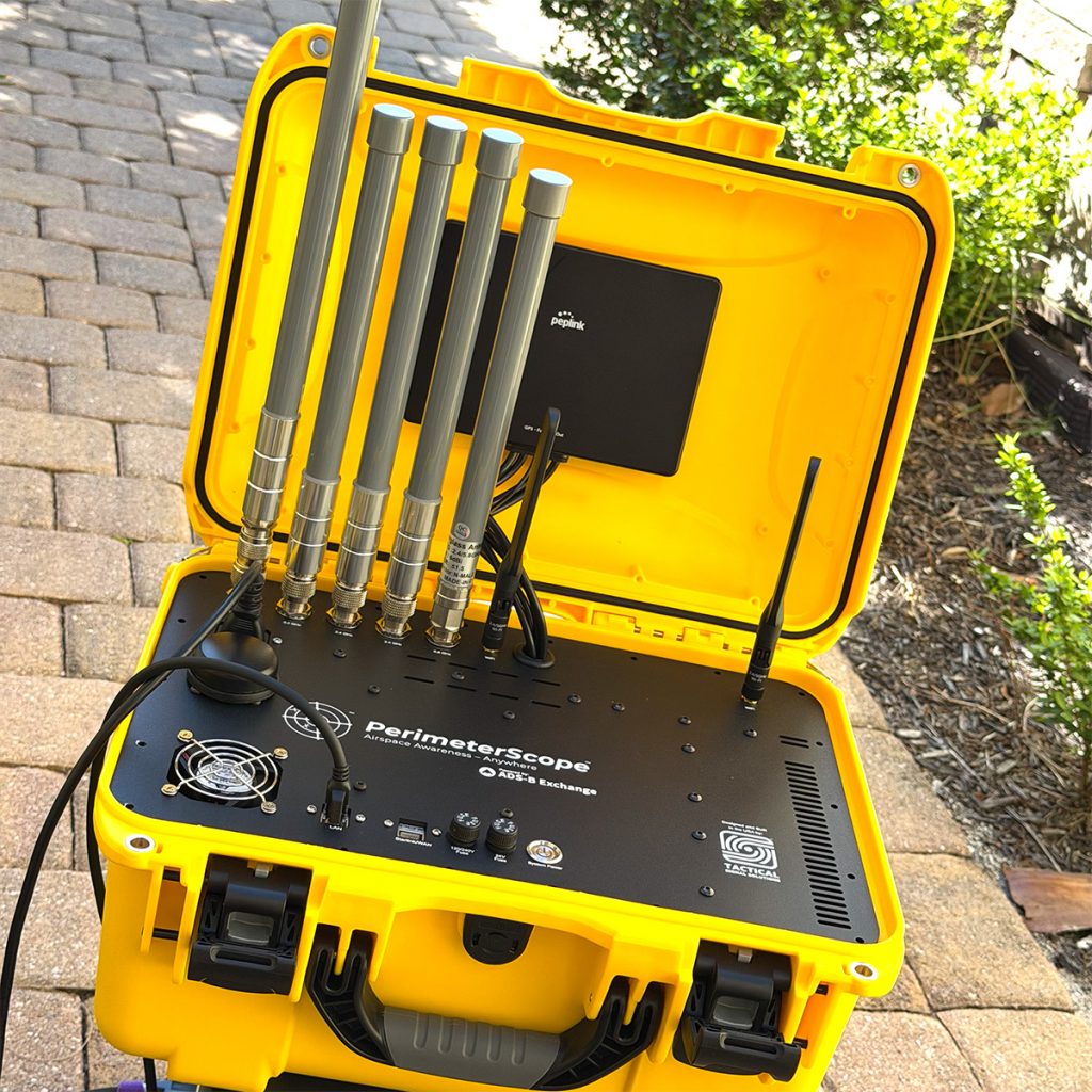
PerimeterScope is built to give command staff, air operations personnel, and law enforcement a better understanding of what is happening in and around incident airspace. By integrating drone Remote ID awareness with ADS-B and UAT aircraft tracking, PerimeterScope helps create a more complete operating picture. Instead of relying solely on scattered reports, radio traffic, or a fleeting visual sighting, teams can gain actionable awareness of both crewed aircraft and drones near the incident area.
That matters because better awareness leads to better decisions. If a drone is detected, command staff can understand more quickly where it is, how close it is to operations, and how it is moving relative to incident airspace. That can support faster coordination between Incident Command, Air Operations, Safety, and law enforcement. It can help distinguish between authorized and unauthorized activity. It can reduce guesswork, narrow uncertainty, and give agencies a better chance to respond intelligently rather than react blindly.
PerimeterScope is not about replacing established aviation safety procedures, and it is not about encouraging anyone to take unnecessary risks. It is about helping agencies make informed decisions with better information. In a fast-moving wildfire or complex disaster response, situational awareness is not a luxury. It is a requirement. The faster a team can understand a drone threat, the better its chances of protecting the airspace, preserving operational tempo, and keeping resources working where they are needed most.
The larger point is simple. A drone intrusion is not just an airspace issue. It is a mission issue. It is a safety issue. It is a cost issue. It is a community protection issue. When firefighting aircraft are delayed or damaged, the fire gains time and opportunity. That can mean more acres burned, more structures lost, more money spent, and more lives put at risk.
We already know this threat is real. We have already seen the consequences. The question is whether agencies will continue facing it with fragmented awareness and delayed decisions, or whether they will equip themselves with tools designed to provide a clearer view of the operating environment.
PerimeterScope was built for that mission. It helps agencies see more, understand more, and respond faster when unauthorized drones threaten emergency operations. In an era when a single drone can disrupt an entire aerial firefighting effort, that kind of awareness is no longer optional. It is essential.
Ready for better awareness? Request your demo today.
Request a Demo