When disaster strikes, uncertainty becomes a threat of its own
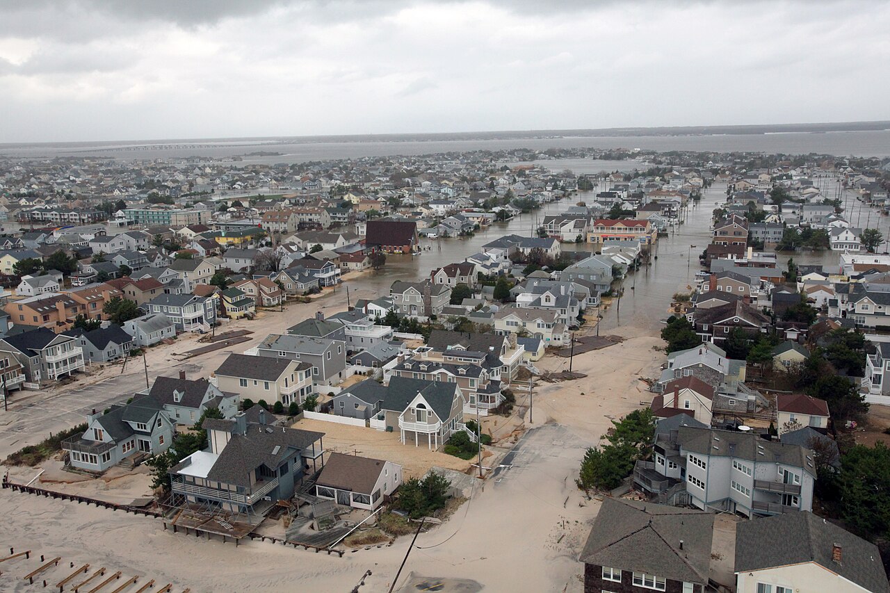
Disaster response is never clean, orderly, or predictable. Communications fail. Infrastructure is damaged. Roads are blocked. Command posts are improvised. Agencies converge from multiple jurisdictions. Helicopters, fixed-wing aircraft, and drones begin moving through the same operating environment, often within hours. Relief flights arrive. Public safety aircraft launch. Unmanned systems are deployed for reconnaissance, damage assessment, and overwatch. The airspace becomes crowded fast.
That is exactly when airspace awareness matters most, and it is often exactly when it is hardest to maintain.
In a degraded disaster environment, responders cannot afford to operate on assumptions. They cannot rely on fragmented radio reports, occasional visual sightings, or incomplete information passed from one team to another. When command staff do not have a clear picture of what is happening overhead, risk grows quickly. Aviation conflicts become harder to avoid. Drone activity becomes harder to interpret. Coordination slows down. The mission becomes more dangerous, more expensive, and less effective.
This is not a technology problem in the abstract. It is an operational problem for emergency management, public safety, disaster relief, and incident command. If you do not understand your local airspace during a disaster response, you are already behind.
The airspace over a disaster zone gets complex fast
One of the biggest mistakes people make is assuming that disaster airspace is only an aviation issue. It is not. It is a command issue, a safety issue, and a mission execution issue.
A helicopter may be inbound with supplies while another aircraft is departing a temporary landing zone. A public safety drone may be flying a damage assessment mission while manned aircraft are operating nearby. A reconnaissance platform may be working a broad area while multiple agencies are attempting to coordinate field operations on the ground. In a large response, those layers stack quickly. If the common operating picture is weak, the burden falls on individual people to sort out conflicts manually under pressure.
“Better airspace awareness helps reduce surprises, and surprises are exactly what disaster teams do not need.”
That is where mistakes happen.
It starts with uncertainty. Then uncertainty turns into delay. Then delay turns into degraded coordination. In disaster response, those delays carry real consequences. They can slow relief operations, complicate aviation safety, reduce situational awareness for command staff, and create avoidable friction between teams that should be working from the same picture.
Government agencies and emergency management organizations already understand the importance of ground situational awareness. The same standard must apply to the airspace above the incident. In modern disaster response, airspace awareness is not an extra capability. It is part of maintaining control.
Remote ID changed the landscape, but only if you can see it
The growth of drones in public safety and disaster response has created both opportunity and risk. Authorized drones can be valuable tools for reconnaissance, infrastructure inspection, perimeter assessment, search operations, and damage documentation. They can help agencies see more, move faster, and make better decisions.
But drones also complicate the operating environment.
Not every drone over a disaster zone is friendly. Not every drone belongs to a government agency, an emergency management team, or a public safety operator. Some may be flown by media. Some may be flown by contractors. Some may be flown by hobbyists or by people who have no business operating near an active response. In a crowded emergency environment, the difference matters.
That is why Remote ID matters.
Remote ID gives responders an opportunity to detect and identify compliant drone broadcasts in the local operating area. But Remote ID by itself is not enough. Data has no operational value if it is not visible to the people making decisions. Emergency managers, command staff, and public safety operators need a practical way to turn Remote ID awareness into usable airspace awareness. They need to know what is there, where it is, and whether it may affect ongoing operations.
That is where PerimeterScope changes the equation.
PerimeterScope helps command staff see the airspace they are responsible for
PerimeterScope is built to bring practical airspace awareness to disaster response, emergency management, and remote operations. It helps agencies build a clearer understanding of what is happening in and around the airspace that matters to them by bringing together awareness of crewed aircraft and compliant drone activity in one operational picture.
Instead of forcing teams to rely on separate systems, partial reports, or delayed communication, PerimeterScope helps create a more usable view of the environment overhead. That matters for incident command. It matters for public safety aviation. It matters for emergency operations centers. It matters for field teams trying to support a mission that is evolving by the hour.
In a disaster, situational awareness breaks down in layers. Communications become patchy. Infrastructure is damaged. New aircraft arrive. Drones appear. Temporary landing zones become busier than expected. Operations expand. The more dynamic the response becomes, the more valuable a clear local air picture becomes.
PerimeterScope is designed for exactly that environment.
Built for disaster response, not ideal conditions
A disaster zone is not a normal operating environment. It is degraded, improvised, fast-moving, and often partially off-grid. Systems built around stable infrastructure and ideal connectivity are often poorly matched to the realities of emergency response.
PerimeterScope is built around field reality. It is intended for the kinds of environments where responders need practical situational awareness even when communications are degraded, infrastructure is unreliable, and normal monitoring may be incomplete or unavailable. That makes it relevant for emergency management agencies, public safety organizations, disaster response teams, incident command staff, and government operators who need a stronger understanding of their airspace during high-consequence operations.
This is especially important when multiple aircraft and drones are operating in the same response environment. Without a stronger local air picture, command staff are forced to answer critical questions too slowly and with too little confidence. Is that drone part of the response, or not? Is aircraft activity increasing near the operational area? Is a detected drone moving toward active aviation operations? Is the airspace becoming more crowded than the team can safely manage with radio calls and visual reports alone?
Those are not minor questions. In a disaster environment, they are command questions.
Better airspace awareness supports better emergency management
Airspace awareness affects much more than aviation safety. It affects the overall effectiveness of disaster response.
When emergency managers and command staff can understand what is happening overhead, they can coordinate more effectively across agencies, improve operational tempo, and maintain a stronger common operating picture. They can communicate with greater clarity. They can make better decisions with less guesswork. They can support incoming aircraft more effectively. They can interpret drone activity faster. They can adapt more confidently as the mission grows in complexity.
That matters because disasters do not remain static. A localized response can expand rapidly. Additional agencies can arrive. Public safety drone operations can increase. Supply flights can multiply. Search and rescue activity can intensify. Temporary aviation hubs can become congested. As the response footprint grows, so does the penalty for poor awareness.
PerimeterScope helps agencies stay ahead of that complexity by making the air picture more understandable before confusion turns into conflict.
Government and public safety agencies need more than fragmented awareness
For government users, emergency management professionals, and public safety decision-makers, the issue is straightforward. Disaster response depends on command and control. Command and control depends on awareness. If the airspace over the incident is not well understood, the entire operation becomes harder to manage.
PerimeterScope helps address that gap by supporting local airspace awareness in the very environments where uncertainty is most expensive. It helps agencies move beyond fragmented awareness and toward a more practical, actionable understanding of aircraft and drone activity in the response area.
That is important not only for safety, but for accountability, coordination, and mission success. The more agencies rely on drones, aviation assets, and distributed field teams, the more important it becomes to maintain a dependable view of the airspace that connects them.
Disaster response is hard enough without being blind overhead
Responders already face enough uncertainty in a disaster zone. They should not have to operate blind to the airspace above them.
PerimeterScope helps emergency management and public safety teams build a clearer understanding of local air activity, including compliant drone broadcasts through Remote ID awareness and aircraft activity relevant to the mission. That supports stronger situational awareness, better coordination, and more informed operational decisions in the moments when those things matter most.
In disaster response, awareness is not optional. It is operationally essential. The agencies that can see more clearly will coordinate better, respond faster, and operate more safely when conditions are at their worst.
Bring stronger airspace awareness to your disaster response mission
If your agency operates in disaster zones, emergency response environments, remote field conditions, or multi-agency incidents where drones and crewed aircraft may be sharing the same airspace, PerimeterScope is built to help you restore clarity when the mission cannot tolerate guesswork.
Request a demo to see how PerimeterScope can support disaster response, emergency management, Remote ID awareness, and real-world airspace awareness where it matters most.
I can also turn this into a version with a more federal procurement tone or a version tailored specifically for emergency management directors, fire command, or law enforcement aviation units.
Ready for better awareness? Request your demo today.
Request a Demo